-
-
-
Scott..
Am I reading this wrong. As I see it, if you are cleared to WAGNR, cleared for the approach, there is only a smart turn to final approaching ORTMN. Unless you meant if approaching from anywhere outside of the NOPT semicircle, but then you would not be on the segment, you would go direct ORTMN and HILPT.Bill -- If you are flying the segment from WAGNR to ORTMN, and there is no NOPT on the chart, then you must fly the HILPT.Comment
-
Hi Scott,Originally posted by Scott Dyer HPN/NY View Post
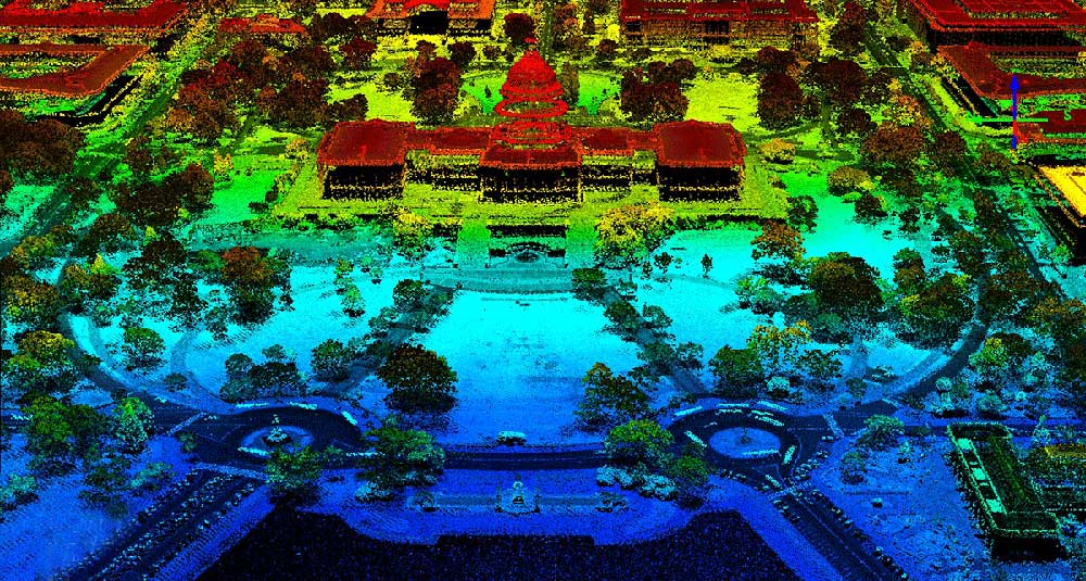
Here’s my kind’a skywrite’n!
Back on 4/26/2018 south of Miami with one of the airplanes I use to fly.
Cessna TU206 @4,000' with a LiDAR sensor. 20:07 EDT~23:21 EDT
One way to drive ATC nuts. <grin>
Regards,
Tom Charlton
"The aeroplane has unveiled for us the true face of the earth." - Antoine de Saint-ExuperyComment
-
OK...reread, you threw in a hypothetical, not this actual situation. (Roseanne Rosannadanna, Never mind))and there is no NOPTComment
-
-
Bill - You could do a direct entry, and turn to 144 outbound when direct ORTMN from WAGNR, that's ok too. And in civil flying, you can do just about any old course reversal (on the designated side of the course) that you want to do when a regular procedure turn is depicted.Originally posted by Bill Bridges View Post
I'm not sure what you're getting at about a difference between FAA/DoD plates and Jepp in depicting HILPTs or PTs....today, anyway, they are pretty much the same and all derived from the underlying regulatory approach description. The only thing about HILPTs in civil flying is that you must "enter the hold" when the HILPt is required...but entering the hold merely means that you cross the holding fix on the entry, you needn't do a circuit. Thus, for the HILPT that is illustrated, if you decided to do a teardrop entry on reaching ORTMN from WAGNR, you would turn to a heading of (about, no wind) 100, fly that for a minute (maybe less depending if there is a tailwind), and then turn right to intercept the inbound final approach course outside of ORTMN. HILPT complete, without having to fly a 144 degree course at all.Comment
-
I will not fly in elongated circles; I will not fly in elongated circles; I will not fly in elongated circles.....Originally posted by Tom Charlton View PostComment
-
If you (as I) thought this was only a speed trap technology...
Comment
-
One of the differences to me is DoD uses a "barb" to indicate a procedure turn while Jepp uses a heavy arrow similar to a "procedure track" for a procedure turn. Some of the places I flew into in the military the course reversal on an approach was actually a procedural track.Originally posted by Scott Dyer HPN/NY View Post
I only started using Jepp charts a couple of years ago when by chart service switched to them and I like them. I'd only been using DoD/FAA charts for 48 years. I know I'm old. ROFL
I really do enjoy these conversations about instrument flying. They remind me of the best job I ever had, an Instrument IP. The flying didn't get any better for me than flying "H" models 20 hours a week with an instrument student.
Thanks for taking time out of your busy schedule to visit with me about this issue.I Earned my Spurs in Vietnam
48th AHC 1971-72Comment
-
Hi Jeff,Originally posted by Jeff Hartmann View Post
Yup. I are intimately familiar with LiDAR. I love the technology. It’s what I done did. Any questions about LiDAR . . . I’m your guy. <g>
Regards,
Tom Charlton
"The aeroplane has unveiled for us the true face of the earth." - Antoine de Saint-ExuperyComment
-
I have a big one with regard to self-driving car technology. The testing seems to be happening in the sunniest, driest places. Around here, headlights and windshields pick up salt spray, snow, slush, and heavy rainfall. What happens when LIDAR gets a snootful of very salty water splashed up by adjacent traffic or gets packed with a wad of slush?Any questions about LiDAR . . . I’m your guy.
Many a time, I have driven roads whose outlines had been obiterated by snowfall. I followed the line of utility poles, etc. and my knowledge of where the road had to be relative to the remaining sight picture.
Dunno what sensors Tesla uses, but one of the reasons it has sped up and crashed into stationary things is the poor angular resolution of its sensors. Above 40 MPH on a highway, stationary objects are ignored. Otherwise, the thing would autobrake for overhead signs, overpass support pillars, etc. Is that a LIDAR issue?Geology rocks, but geography is where it's at.Comment
-
I'm enjoying it (and learning) too, Bill. Can you post a picture of a DoD-style procedure track that must be flown exactly as charted for a course reversal?Originally posted by Bill Bridges View PostComment
-
-
Hi Ray,Originally posted by Ray Tackett View Post
Me too!
Yup. Real world, everyday conditions! With some recent crashes it’s occurred to me . . . could be a fouled sensor.The testing seems to be happening in the sunniest, driest places. Around here, headlights and windshields pick up salt spray, snow, slush, and heavy rainfall. What happens when LIDAR gets a snootful of very salty water splashed up by adjacent traffic or gets packed with a wad of slush?
A fouled sensor could probably be detected 99.99% of the time and problem averted. But there’s that other 0.01% . . . that’s a lot’a crashes. <ng>
Some of these systems may utilize predefined digital maps of basic road alignment. [/speculation]Many a time, I have driven roads whose outlines had been obiterated by snowfall. I followed the line of utility poles, etc. and my knowledge of where the road had to be relative to the remaining sight picture.
Seems like I’ve read that Tesla’s Driver Assist has elected to –not- utilize Lidar. Also not intended for streets and back roads, Interstate only [/speculation]Dunno what sensors Tesla uses,
This type of LiDAR, amazingly, generates a near real-time point-cloud depiction of [almost] everything in the area ahead. The point density would necessarily be sparse in order to process the data quickly enough.but one of the reasons it has sped up and crashed into stationary things is the poor angular resolution of its sensors. Above 40 MPH on a highway, stationary objects are ignored. Otherwise, the thing would autobrake for overhead signs, overpass support pillars, etc. Is that a LIDAR issue?
Many facets to this evolving technology.
* Driver assist v fully autonomous.
* Many kinds of sensors being experimented with singularly and in unison: ie: Sonic, Radar, LiDAR, GPS, Accelerometers, Gyros, Other feedback from the vehicle, +?
* AI to digest all the data and make continuous, real-time, life dependent decisions with it.
Regards,
Tom Charlton
"The aeroplane has unveiled for us the true face of the earth." - Antoine de Saint-ExuperyComment
 Tweet
Tweet

Comment